
2023-10-06, 10:45–10:50 (Europe/London), Poster presentation
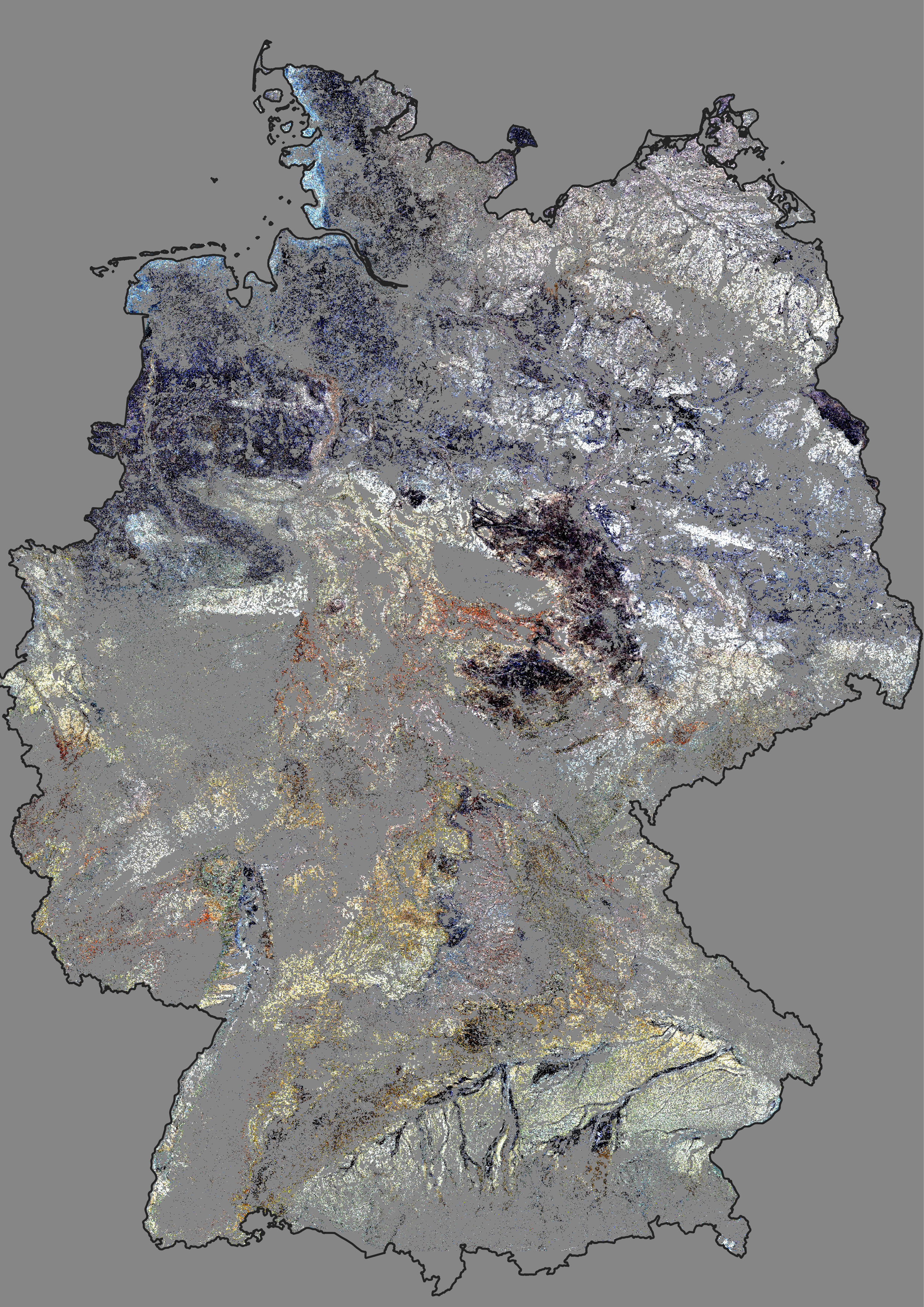
The monitoring of soil organic carbon (SOC) in cropland is crucial, as soil health plays an important role in ensuring sustainable agricultural productivity and in reducing carbon emissions. Remote sensing technologies offer a promising opportunity to monitor soil properties on a large scale. Bare soil maps can be derived from satellite images and used to estimate soil properties, like the SOC content, based on spectral properties. However, analyzing such data requires processing large amounts of information from different sensors and time frames, which can be challenging. The Framework for Operational Radiometric Correction for Environmental Monitoring (FORCE) offers an interface to handle and analyze satellite data cubes and has been successfully used to create analysis-ready data in numerous studies. This work focuses on the generation of soil reflectance composites based on the FORCE data cube and the construction of a bare soil data cube to estimate trends of dynamic soil properties with spatio-temporal machine learning.
Using FORCE, the generation of bare soil maps is optimized for large areas and different time intervals. This can be challenging, as the soil properties across large scales are diverse, especially in regions with extreme conditions. New methods like spatial filters and dynamic thresholds are implemented to improve the representation of different soil regions and to reduce the noise of the soil reflectance composites. The results are stored in a bare soil data cube which is then used as a basis for soil monitoring. By combining this information with other environmental variables, such as climate and topology, the data cube approach can provide a basis to map soil dynamics over time. The bare soil cube is tested by predicting the SOC trends of cropland soils in Germany. Samples from the LUCAS campaigns, as well as from the Agricultural Soil Inventory in Germany (BZE-LW), are used to train and validate the models. The proposed approach has the potential to greatly improve the predictions of dynamic soil properties and to inform better management practices for sustainable land use, climate protection, and policymaking. Furthermore, the use of bare soil data cubes allows for efficient storage, retrieval, and analysis of large amounts of analysis-ready data, making it a practical and scalable approach for soil monitoring on a regional or global scale.
None of the above
I completed my Bachelor's degree in Physical Geography in Hanover and my Master's degree in Geoinformation Technologies in Dresden, Germany. Currently, I am working as a researcher at the Thünen Institute of Farm Economics and pursuing a PhD in the Earth Observation Lab at Humboldt-Universität zu Berlin. My main area of interest is in monitoring agricultural practices and management that have direct and indirect effects on climate. My research methods primarily involve analyzing time series data derived from satellite remote sensing, with a particular focus on combining the strengths of optical and radar sensors.
My name is Tom Broeg and I’m currently working as a researcher in the “Thünen Earth Observation (ThEO)” group, located at the Thünen-Institue of Farm Economics. With our Project “KlimaFern” we are combining methods of remote sensing and digital soil mapping to improve the reportability of carbon emission in the agricultural sector. My work is focused on digital soil mapping and soil science, especially in the context of soil organic matter. In cooperation with the Thünen-Institue and the University of Thübingen, I’m currently working on my Ph.D. and the development of a remote sensing-based soil monitoring system.