
2023-10-05, 11:15–11:35 (Europe/London), EURAC Auditorium
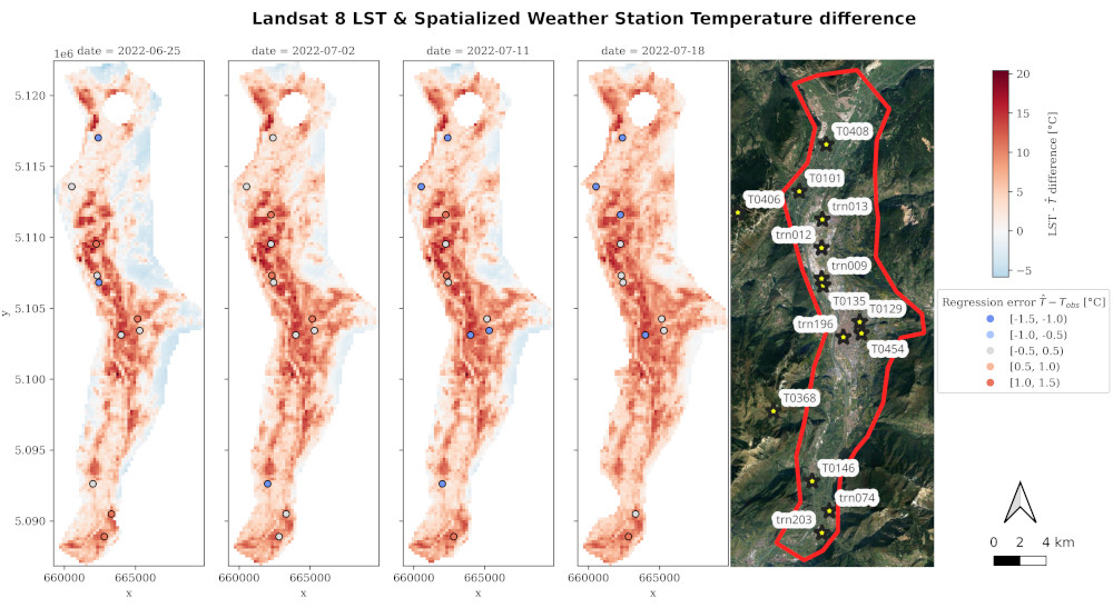
Heat waves are more and more heavily affecting population and this is even more enhanced in cities rather than in the countryside where the urban heat island (UHI) effect worsen their duration and intensity. Current research on the estimation of the UHI effect adopts 3 main approaches: i) observational studies describing its driving processes, spatial patterns and/or magnitude; ii) Earth observation (EO) studies focusing on the surface urban heat island (SUHI) determined from land surface temperature (LST) retrieved from satellite thermal sensors (e.g. Landsat-TIRS, Sentinel-SLSTR); iii) modeling via mesoscale meteorological models like the Weather Research and Forecasting (WRF) or microscale models (i.e. ENVI-met) that require large computational effort and/or fine tuning of parameters. Municipalities need actionable data to support their decisions. It is thus crucial to develop intermediate approaches for the estimation of the UHI intensity and spatial extension without the need of advanced expertise to tune parameters or run complex meteorological models but, at the same time, able to provide reliable insight into the urban air temperature. The work presented in this contribution is performed in the framework of the USAGE project activities and focuses on providing a pipeline for the development of UHI maps in urban areas utilizing open data like EO, IoT ground sensor data, surface properties and a hybrid model based on machine learning and geostatistics. We present a pipeline that can be deployed with minor adaptation (i.e STAC end points) within GIS software environments. The ground sensor data are accessed via OGC SensorThings API and fed into the analysis. Pre-loaded 'semi-static' layers, like DTM, DSM, LU/LC, vegetation fraction, urban building morphology and shade maps are accessed via OGC Feature API and utilized to spatialize the air temperature at each time stamp received from the IoT sensors. Based on the revisit time of EO thermal data and its cloud-coverage level, LST observations are integrated to help the spatialization of the ground sensor's temperature, performed using a hybrid model combining machine learning and geostatistics. This allows for faster computation compared to classical geostatistics but, at the same time, to explicitly handle spatial correlation of data and errors. The aforementioned pipeline is suitable to derive UHI maps from given IoT ground sensor data. On the other end, to forecast the UHI effect up to 48 h, the pipeline ingest 2-m air temperature, relative humidity as well as wind speed and direction from the meteorological models (WRF or AROME) the open-meteo API.
The proposed pipeline is applied in the Alpine valley and city of Trento (Italy) and is then validated against high-resolution simulations with the WRF model, offline coupled with an urban parameterization scheme to reach a resolution of 100 m. The proposed pipeline can be used not only as a forecasting tool, but also as a UHI mitigation and planning tool by changing the ‘semi-static’ layers that involve the study area. This allows municipalities to predict the effects of their decisions.
Raniero Beber [FBK] rbeber@fbk.eu;
Fabio Remondino [FBK] remondino@fbk.eu;
Luca Giovannini [DEDA] luca.giovannini@dedagroup.it;
Piergiorgio Cipriano [DEDA] Piergiorgio.Cipriano@dedagroup.it;
Lorenzo Giovannini [UNITN] lorenzo.giovannini@unitn.it;
Other

Geospatial data analyst at 3DOM research unit, FBK Trento, Italy
https://3dom.fbk.eu/people/profile/beber