
2023-10-05, 14:05–14:25 (Europe/London), EURAC Auditorium
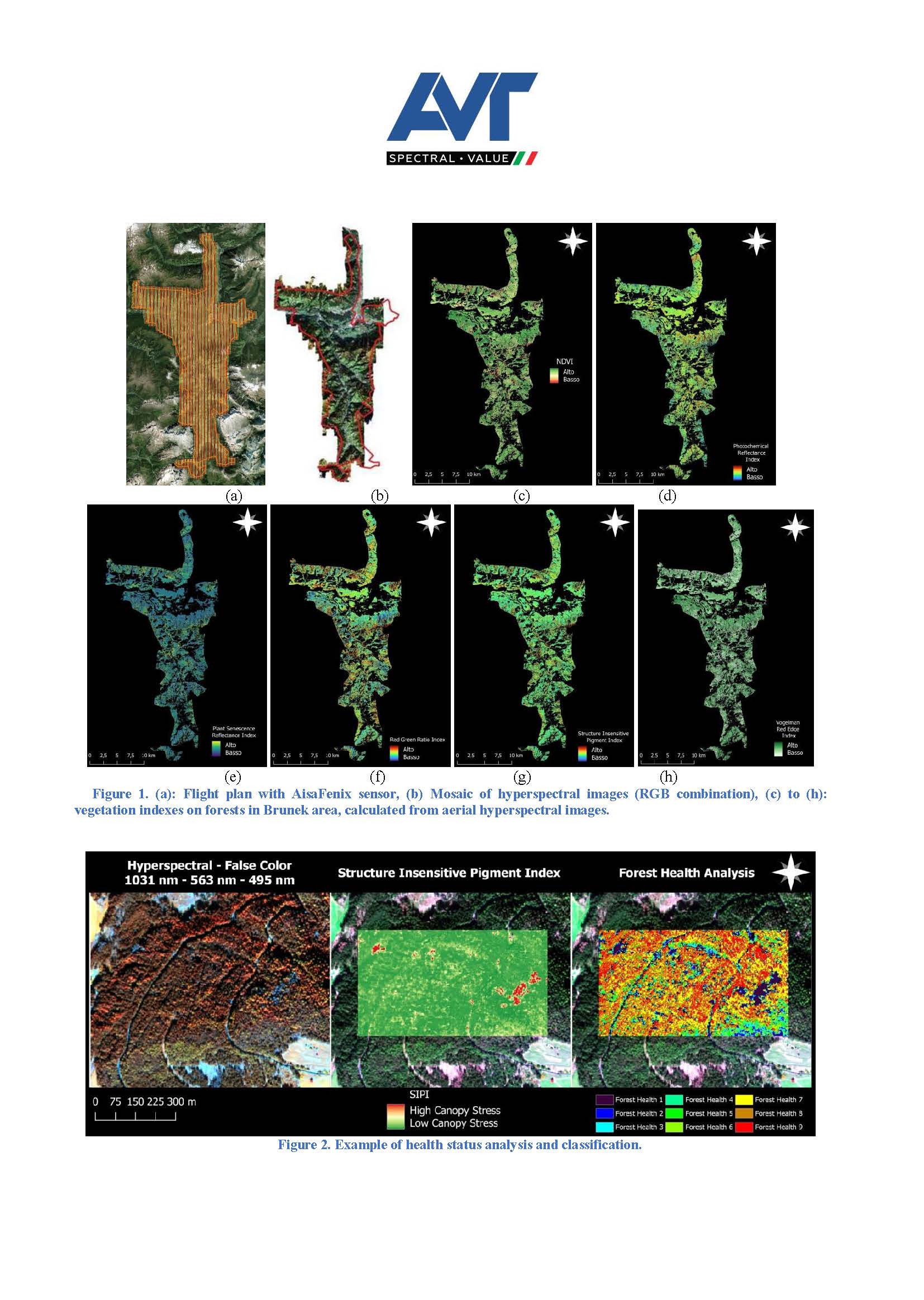
Extreme weather and outbakes phenomena are occurring more and more frequently and are affecting forests throughout the Alpine region. Efficient and targeted forest management on a municipal, provincial or regional scale requires high quality, information-rich remote sensing data. Airborne hyperspectral imagery enables the acquisition of high-resolution data on entire portions of land in a short space of time, whereby the high amount of spectral information provides efficient tools for forest managers, such as mapping forest species, identifying invasive species, mapping bark beetle damage, calculating narrowband vegetation indices and analyzing health status. AVT Airborne Sensing Italia (AVT-ASI) uses the Specim AisaFenix sensor for hyperspectral image acquisition. The sensor works in the VNIR and SWIR spectral ranges and acquires 384 bands in pushbroom mode. At the beginning of October 2022, AVT-ASI acquired hyperspectral images over a forest area with size 350 km² near Bruneck, in the South Tyrol province, Italy, (Figure 1 a and b) to support the local forestry inspectorate in the evaluation of the forest health status. Indeed the area of interest has been strongly affected by the spread of the bark beetle, probably due to the damages caused by Vaia storm in 2018, followed by dry periods. The AisaFENIX images were preprocessed to correct atmospheric, radiometric and geometric effect, and then the most frequent tree species were mapped with machine learning algorithms. For the Picea abies (Norway spruce) class, further analysis were conducted using multiple narrowband vegetation indices (Figure 1 c to h), in order to assess the health status of the trees (Figure 2) and detect the effects of the presence of the bark beetle. The results have been validated by the forestry inspectorate with ground surveys. The georeferenced thematic product obtained by the hyperspectral aerial images resulted to be very useful for optimal forest management, in particular for the identification of possible infected trees at an early stage (green-attack) and the implementation of mitigation measures. The information was available at a degree of accuracy that is not achievable by VNIR + SWIR images acquired by satellite platforms, due to the low spatial resolution. However the availability of regular and frequent satellite images has the potential to allow for temporal analysis and change monitoring, starting from the detailed as-is situation obtained from the aerial hyperspectral images.
The presentation will show the scientific approach of the work done and critically discuss the achieved accuracy in the intermediate and final products.
OEMC Grant agreement ID: 101059548
Thomas Maffei holds a master degree in environmental science from the University of Padua. He has focused his studies on the application of remote sensing data in the environmental field, and works as a remote sensing expert at AVT-ASI. He's responsible for the processing and analysis of hyperspectral images acquired in Europe with the fleet of AVT group.